Quilt of Many Colors
Autumn weaves wonders on the Patchwork Parkway
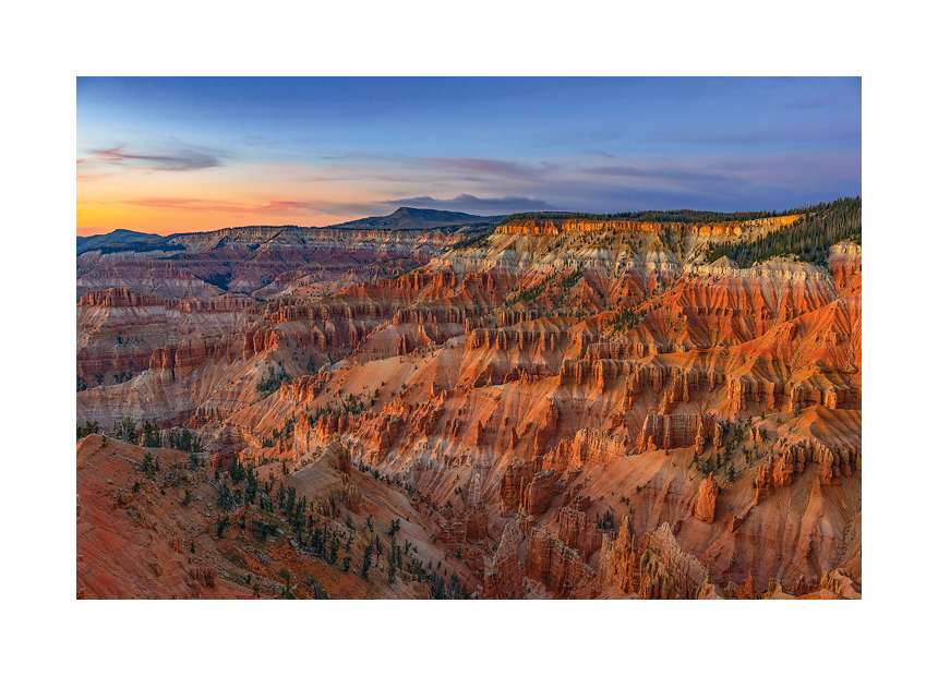
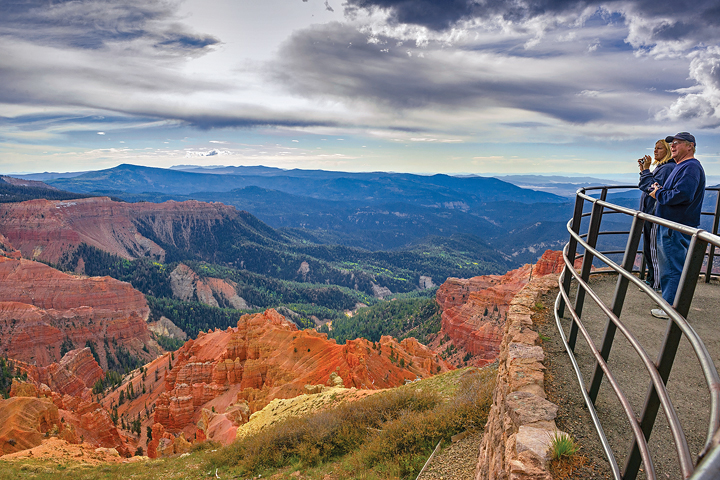
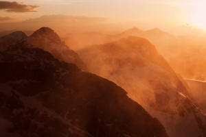
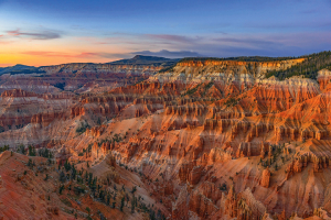
Cedar Breaks National Monument sunset.
JOSHUA HARDIN
WITH WINTER’S ICY grip tightening its hold and food supplies dwindling daily in the fledgling Southern Utah settlement of Panguitch, seven men set out for the nearest city, Parowan, on a mission to save the starving families they left behind. The 45-mile trudge over a high mountain pass in late 1864 wouldn’t be easy. They drove a light ox wagon as far as they could before it foundered in a deep snowdrift. The men continued on foot, but their legs sank in the snow, and every step led to an increasingly desperate sense of exhaustion.
The men realized traveling this way would be impossible, but there could be no turning back empty-handed. In the seemingly hopeless situation, the group knelt together on a quilt and prayed for God’s guidance. While kneeling, the men discovered the quilt evenly distributed their weight – they didn’t sink into the snow! The quilts knitted lovingly by their wives not only provided warmth but also became the key to their passage over the mountain. They resumed by painstakingly laying one blanket after another to create a quilted pathway to walk on all the way to Parowan. After securing the needed flour, they returned the way they came, walking for an estimated 10-14 days on quilts to deliver the provisions to their hungry households.
The 1864 “Quilt Walk” inspired a modern highway over the pass called the Patchwork Parkway. Today’s travelers have it easier than pioneers did. The treacherous trek that took the quilt walkers weeks to complete is now a pleasurable stretch driven in a matter of hours, but most motorists will want to take their time to appreciate all the sights autumn stitches together along the path. Also called Scenic Byway 143, the 55-mile paved ribbon of roadway weaves through landscapes rainbowed by eroded orange cliffs, aspen forests checkered with golden leaves, trout-stocked turquoise lakes and historic towns lined with red-brick bungalows.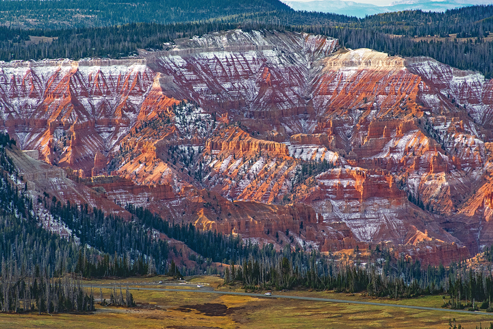
THE QUILT WALKERS weren’t the first to cross between the close-knit communities of modern Panguitch and Parowan, the Parkway’s western gateway along busy Interstate 15, where more than 600,000 cars pass yearly. Migrations have always been a way of life. Archaeological evidence suggests American Indians used the route from desert wintering grounds to mountainous summer hunting-and-gathering lands for more than 12,000 years. Eleven miles west of the interstate at the Parowan Gap, Fremont and Paiute tribes carved rock art into a 600-foot crevice where an ancient river once flowed.
According to Southern Paiute legend, a prominent petroglyph illustrates an exodus when a great leader brought his followers along a trail fraught with famine and drought to a lush new land beyond the gap. However, strife ensued when the people settled, and the leader was murdered. He is shown as a head and body with no arms, upside down with an arrow inside the top of his head, indicating he knew he would sacrifice his life for peace.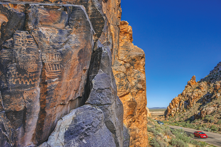
Early 19th-century horse traders and mule trains stocked with woolen goods on the Old Spanish Trail stopped to rest in the region. In 1850, The Church of Jesus Christ of Latter-day Saints leader Parley P. Pratt, following the trail, discovered deposits of iron ore and coal, leading Church of Jesus Christ of Latter-day Saints President Brigham Young to plan immediate colonization of Southern Utah. Less than a year later, pioneers established a permanent settlement below the very flagpole Pratt had planted at his camp.
Settlers initially called their home “The Little Salt Lake” after a small, briny lake to the west. They soon renamed it Parowan, a Paiute word meaning “evil water,” inspired by tales of a monster that pulled a tribal maiden into the lake. The lake is nearly dry today, but Pratt’s flagpole still stands above a natural spring that nourished early colonizers. Some got to work building homes and the stately Rock Church, the oldest in Southern Utah, while others, especially immigrants from the British Isles skilled in mining and ironworking, labored in smelters from Parowan to Cedar City, 19 miles south.
Parowan became the new Iron County seat, but the hills produced lower amounts of high-quality ore than expected, and mining quickly declined. Many Parowan pioneers were called to establish new settlements throughout the West. Because of this, Parowan is considered the “mother town” of Southern Utah. This honor sometimes came at great cost. Visitors can self-tour the city cemetery where several wives were buried alone after their husbands were sent to other settlements. Visitors can also see the spring, a sculpture of Pratt and accounts from other Parowan founders within Heritage Park or visit the church, now a Daughters of Utah Pioneers museum, possessing one of the region’s largest historical photograph collections, by appointment.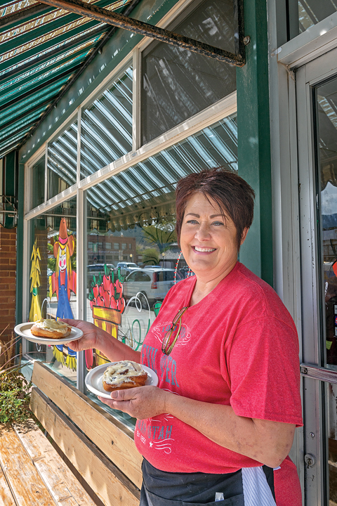
THOSE WHO DON’T stop in Parowan for petroglyphs or pioneer history might be lured from the interstate by two billboards promising the “Best Cinnamon Rolls in the West.” More than two dozen Parowan businesses partner in the city’s “Sweet Tour,” which the community conceived as a fun way for people to explore the town.
“We’ve always had cinnamon rolls,” Parowan Cafe owner Katti Lister said. “We just make a lot more of them now.” The rolls at her cafe helped inspire the citywide tour, and they lend credence to the billboard’s boast. A customer recently confided to Lister that her cinnamon rolls had bigger flavor than the favorite 5-pound behemoths of her Texas hometown. “People laughed at us,” Lister said. “They said we were crazy. But they didn’t realize there were so many cinnamon connoisseurs in the world.”
The cafe has been on Main Street since 1948 and in Lister’s family for the last 22 years, serving rolls the whole time. It takes 44 gallons of cream cheese weekly to prepare the freshly baked from-scratch rolls – a difficult task for a short-order kitchen. The daily supply usually sells out by 2 p.m.
“Locals are just as into it as the tourists. If the rolls aren’t ready at a certain time, they’ll throw a fit,” Lister said. Rolls come with or without raisins, and Lister is experimenting with pumpkin, orange and peach-cobbler flavors premiering this fall.
Some of the city’s other unique cinnamon creations are milkshakes made with crystallized sugar at the Dairy Freeze, strawberry- filled churros at La Villa Mexican Restaurant, chimichangas at Calvario’s Family Restaurant and even cinnamon-scented candles at Bev’s Floral & Gifts and cinnamon- hued hair coloring at Barber J’s. Parowan Events Coordinator Jet Smith said her personal favorites include cinnamon honey, as well as T-shirts imploring, “Come check out our buns,” sold at the visitor center where she works.
The Sweet Tour isn’t the only smalltown appeal awaiting autumn adventurers in Parowan. Through October, residents decorate 150 hay bales along the streets with scarecrows, such as the one the high school football team suited up in gridiron gear. On October 13, the Fall Festival in the Park brings an old-fashioned car show, costume parade and farmers market to the library grounds.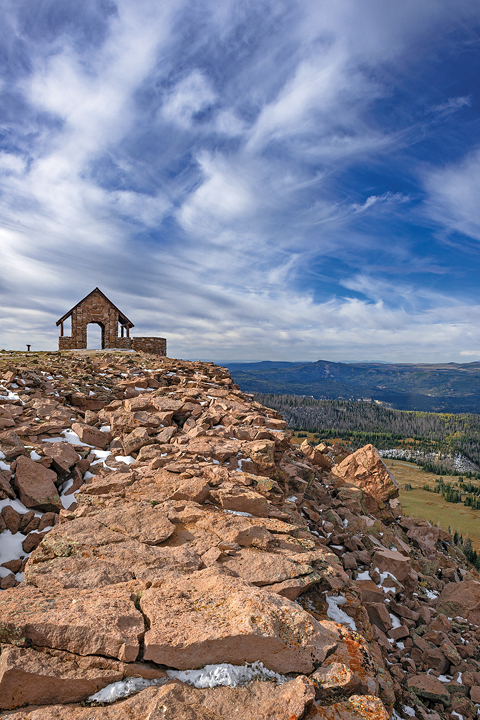
A SUGAR RUSH isn’t necessary to experience the exhilaration of driving the curvy Parowan Canyon road toward Dixie National Forest. Though the byway is edged by remnants of a 2017 wildfire that burned more than 71,000 acres, aspen trees are already growing under skeletal singed conifers, and visitors are returning to the affected communities.
One such community is Brian Head, named for the 11,307-foot peak rising above it. The origin of the peak’s moniker is unknown. Early surveying expeditions marked the reference point as Monument Peak, but the name changed by the turn of the 20th century. Some claim that explorer John Wesley Powell named it for a Geological Survey Office official named Bryan, while others say it was named for the politician William Jennings Bryan or a prominent Parowan family with the same surname. Regardless of its origin, the name Brian Head is a perennial source of confusion, Brian Head Resort Marketing Director Ron Burgess said.
“We get calls for Brian all the time,” Burgess said. “They ask me, ‘Hi Brian, how are you?’” This isn’t the only challenge at Brian Head. As the highest-elevation incorporated community in Utah, the shoulder season between summer and winter is short. Real estate developer Burton Nichols found it easy to attract winter sports enthusiasts when he converted an obscure timber outpost into Brian Head Resort in 1964. The ski area thrived, with an average of 350 inches of annual snowfall making it one of the snowiest inhabited places in the United States. Getting visitors to linger in warmer months took more effort, so the community built more than 200 miles of downhill, single-track and cross-country mountain biking trails that remain open in September.
Non-velophiles enjoy Brian Head’s festivals, like Rocktoberfest, which serves German-inspired grub and libations on September 15, or driving to the peak’s stone summit shelter built by the Civilian Conservation Corps. Reached via a gravel spur road from the Patchwork Parkway, the breathtaking panoramic view from the summit looks out across more than 100 miles, including aspen forests dappled in fall foliage, the gleaming white sands of the Great Basin Desert and the craggy red-rock cliffs of Zion and Bryce Canyon national parks.
BELOW BRIAN HEAD, the byway skirts the northern edge of Cedar Breaks National Monument, which encompasses a 3-mile-wide, 2,000-foot-deep canyon the Paiute called “U-map-wich,” meaning “the place where the rocks are sliding down all the time.” Later settlers misidentified juniper trees as cedars and described the steep terrain as breaks.
The monument’s main attraction is a natural amphitheater displaying a dazzling array of vibrant maroon and coral-colored formations carved from limestone. Broad rock ridges, or “fins,” that protrude from canyon edges are exposed to erosive geologic jackhammers like rain and snow until holes form at their bases to create arches. Pinnacle-like hoodoos remain when these openings break from the stress of freezing and thawing ice. The spires seem to glow like radioactive creatures and throw spooky shadows when seen from Point Supreme overlook at sunset.
Though the geology is similar, Cedar Breaks is twice as deep and located 2,000 feet higher than its cousin Bryce Canyon, creating a grander scale, according to park ranger Shannon Eberhard. Its high altitude makes Cedar Breaks a prime star-watching spot and a designated International Dark Sky Park. Locals keep telescopes in their vehicles but say they’re not needed – they’re already so close to the stars it feels like they can reach out and touch them. The monument hosts a star party, a biologist- led “bat chat” and a night sky photography workshop during the Southwest Astronomy Festival on September 8.
“It never gets old to get a perspective of your place in the universe. Even dark sky experts from all over the world are surprised when they visit,” Eberhard said, adding that stargazers have seen iridium flares from satellites, flickering green auroras and meteor showers they might not have spotted in the hazier skies above lower observation points.
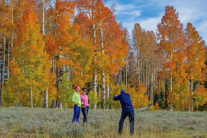
The Markagunt Plateau on the monument’s eastern outskirts houses more than 350 fish and wildlife species. Fall is mating season for the bull elk that bugle haunting calls through the plateau’s aspen forests, and it is hunting season for the humans who seek them. “The clever elk come into the monument because they know the hunters can’t follow them,” Eberhard said.
Leaf-peepers scan plateau aspen stands for a different quarry: unusual ruddy-colored leaves. It’s uncertain why some of the aspen leaves here turn red instead of their characteristic yellow. Theories include differing annual moisture levels, the genetic predisposition of certain pockets or a minerally rich soil composition remaining from ancient lava flows.
Under sheer black volcanic rock cliffs, the byway veers northeast, crossing into Garfield County and the community of Panguitch Lake, encircling the brilliant sapphire blue waters of its namesake. Panguitch means “big fish” in Paiute, and anglers flock to the site year-round to catch trout regularly reaching lengths longer than 20 inches.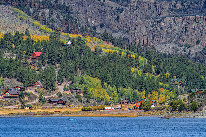
THE HIGHWAY DROPS into a valley below the lake and is punctuated by the city of Panguitch. The city’s charming downtown is a national historic monument and hot spot for antique and jewelry shoppers. There’s a good reason Panguitch has so many historical bungalow homes in the Arts and Crafts style made of red brick: A local brick factory used to pay employees in brick instead of cash.
Notorious bank robber Butch Cassidy was a Panguitch-area resident. A log cabin where he grew up is located 25 miles north on U.S. Highway 89. Tourists pose for selfies with mannequins dressed like Cassidy and the Sundance Kid at Cowboy Collectibles, and other downtown stores are well-stocked with Cassidy memorabilia. Despite the outlaw’s fame, many locals aren’t so impressed.
“As far as I’m concerned, he was a crook,” said Barbara Talbot of the Daughters of Utah Pioneers Panguitch Museum. Her great-great-grandfather William Talbot was one of the seven quilt walkers. Long-time residents celebrate them as the real local heroes.
“We’re grateful that the walk happened,” Talbot said. “It meant that we are here to stay.” She estimates half of Panguitch’s 1,500 residents are related to the quilt walkers, and there are just as many more who live elsewhere but come back for reunions. The Quilt Walk Festival, featuring a parade, quilting classes and historical re-enactments, honors the walkers each June, but descendants make pilgrimages year-round to Quilt Walk Park, where a sculpture of a walker commemorates the event. These present-day homecomings recall the same joy the original walkers may have felt to see their families again.

“The whole settlement welcomed us, because we had been gone longer than expected,” quilt walker Alex Matheson described after his return. “There had been prayers, tears and fears which turned to rejoicing and cheers.”
Whether coming home to family or traversing it for the first time, Patchwork Parkway travelers will be warmly welcomed at every bend, even when a crisp, chilly snow blankets the mountain slopes. The persevering pioneers’ quilt-paved trail created an enduring link between Panguitch and Parowan, and the modern byway binds the communities together in the same spirit of friendship.
This story first appeared in the September/October 2018 issue of Utah Life Magazine.
The information below is required for social login
Sign In
Create New Account